A Century of Tweaks: Westover Hills as a Work in Progress
by John M. Coski
In December 1948, the Westover Hills Corporation informed the State Corporation Commission that it was “ready to liquidate its assets because it has sold most of its ‘more desirable building sites,’” and petitioned to transfer its assets to its subsidiary, the Boulevard Bridge Corporation. Westover Hills was, for all intents and purposes, “complete.”
Or was it?
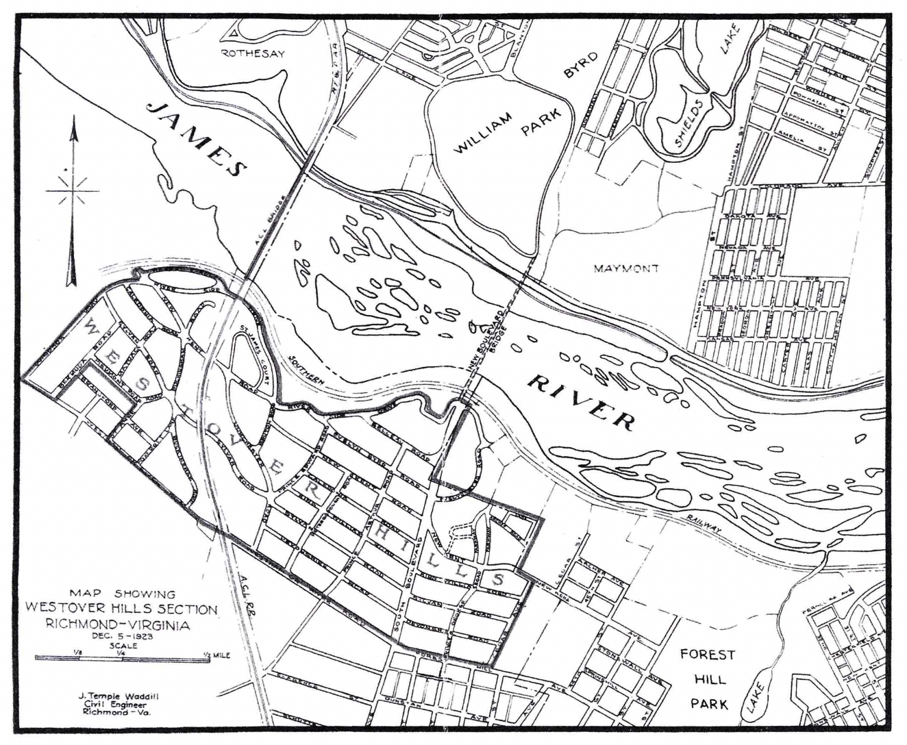
For evidence that Westover Hills long remained a work in progress, we need only examine two historical publications that the WHNA has produced: the reprint of the 1935 silver promotional booklet Westover Hills: “Richmond’s Most Beautiful Suburb” and the 1928 neighborhood plat map.
A page in the 1935 booklet entitled “Some Road Names in Westover Hills and Their Derivation” includes two names you will not find on neighborhood street signs today (Belleau Rd. and Buckingham Rd.) and two others (St. James Court and Regent Circle) that came into existence with Westover Hills West in the 1980s. The 1928 plat map clarifies that Belleau Rd. was what we know as the 5000 and 5100 blocks of Riverside Dr., and (the original) St. James was the current 5500 block of Riverside.
Street name changes were not uncommon. For example, an initial (October 1923) plat showed Devonshire and Sylvan roads as Warwick and Essex roads, respectively. The renaming of several blocks of Riverside reflected a more substantial revision of the street plan.
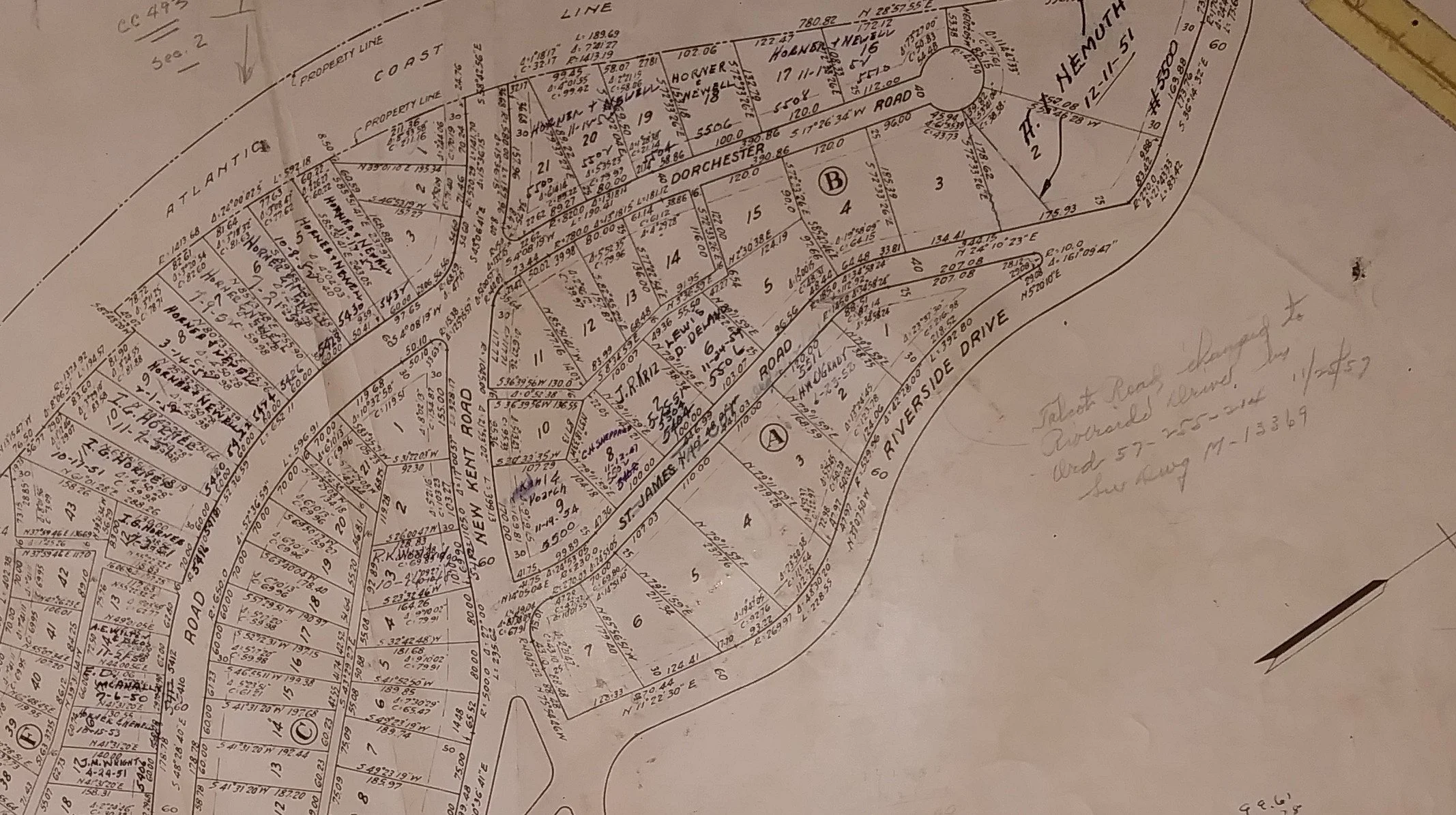
The original plans for a scenic riverside drive routed it along the contours of the hill below the houses on the north side of modern Riverside. Architects designed several early homes with their decorative facades facing the original road right-of-way. Significantly, the 1928 plat map noted that several sections of Riverside were “not open.” See Map A
Map A
By 1931, however, it became clear that constructing a road along the brow of a steep former quarry was not feasible. New plats were issued extending the lots across the original Riverside Drive right-of-way to the Southern Railway right of way that runs along the river.
It took several decades for street names to reflect this concession to reality: Belleau remained in city directories through 1953. A penciled note on an archived copy of the 1931 plat replaced “St. James Road” with “Talcot” Rd. A copy of a late 1920s plat map shows “St. James Road” scratched out and replaced by “Talcot” with an additional penciled notation that “Talcot Road changed to Riverside Drive by Ord[inance]… 11/25/57.” See Map A
Regardless of city ordinances, (unofficial) city directories included both St. James and Talcot roads into the mid-1960s. One long-time resident recalls coming home from school to find city workers replacing the Talcot Rd. sign with Riverside Dr. Another resident recalls no address for that block other than Riverside.
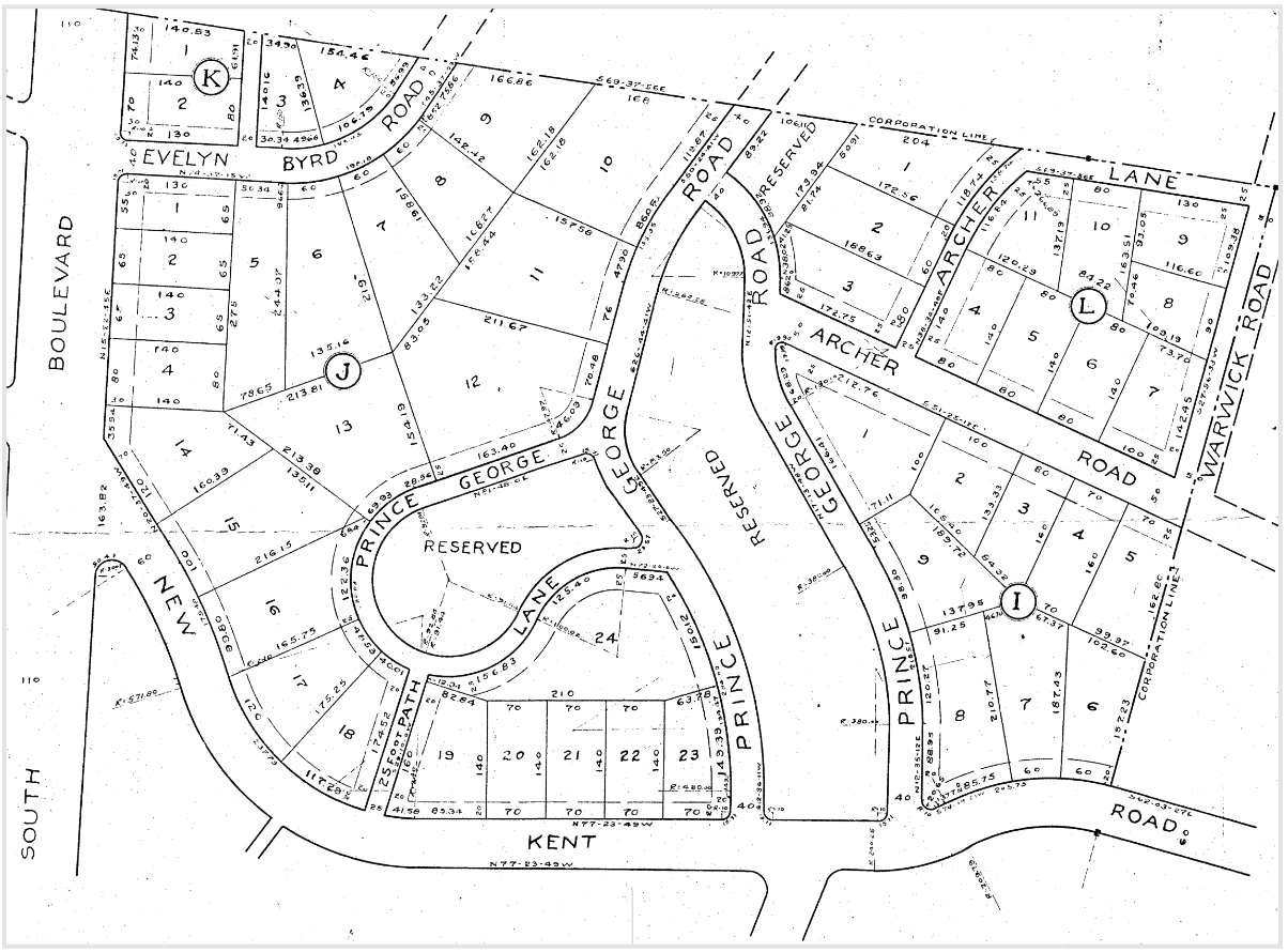
Early plat maps also revealed ambitious plans for Prince George Rd. extending in two arms beyond New Kent down the hillside through and around Wayside Springs (marked as “Reserved”). See Map B Although development of Prince George from Riverside along the west side of the creek continued into the 21st century, the full vision for that section never materialized. Penciled notes on a 1952 plat extending Archer Ave. to the west (which similarly never happened) changed the eastern arm of Prince George first to Warwick Rd. and then, by Ordinance 53-54-53 to Southcliff Rd.
Map B
In contrast, another feature shown on early maps did come to fruition—albeit more than 60 years later. The 1928 plat included lots on Sylvan Rd. extending west of Dorchester to the Atlantic Coast Line (ACL) tracks. Those lots could not be developed, however, because they had no access to utility lines. That situation changed in the mid-1980s with the development of Westover Hills West. In September 1989, attorney / developer T. Craig Harmon and builder Mike Dumont announced plans for a 28-lot subdivision. The 5300 block of Sylvan Rd. and Sylvan Ct.—occasionally mistakenly called “Westover Hills West”—were finally realized.
Westover Hills Annex
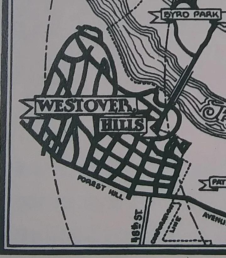
A close look at a rough map in the 1935 silver booklet depicts Westover Hills as a maze of unnamed streets—far more streets to the west than indicated on neighborhood plat maps. See Map C.
Map C
An obscure 1924 promotional brochure issued by James E. Donahue (one of several realtors authorized to sell lots in the newly opened subdivision) attached names to those streets lying on the other side of the ACL tracks. See Map D.
Map D
In addition to Sylvan, Caledonia, New Kent, and Riverside extending across the tracks were streets that evidently were part of another vision never realized: Buckingham, Foxcroft, St. Ann, Piedmont, Bransford, Matoaca, Bermuda, and Windsor.
The ultimate fate of that vision takes us back to the 1948 dissolution of the Westover Hills Corporation (WHC). Among the assets that passed from the WHC to the Boulevard Bridge Corporation (BBC) was a large tract of land the WHC acquired but never platted. Within a year of assuming control of that tract, the BBC sold it to Lind Lawrence, who made plans to develop it as “Westover Hills Annex.”
After overcoming several legal challenges (the property lay within Chesterfield County until 1970, but was, nevertheless, subject by law to some Richmond city regulations), Lawrence’s Elkhardt Construction Corporation began building modest 3-bedroom ranch houses in 1955. A 1951 plat for the Annex indicates that the Buckingham Rd. shown on 1920s map had become Leicester Rd., which was where Lawrence’s company began building ranch houses. (Modern real estate transfers still identify properties on Leicester and Woodburn roads and on the 5500 block of Forest Hill Ave. as “Westover Hills Annex.”)
Described as “a quiet, self-made man” and “an enigma and recluse,” Lawrence died in 1972 and left his estate to a charitable foundation that created, among other things, the Medical College of Virginia neurological research center. His death halted the slow development of Westover Hills Annex and eventually led to the creation of Westover Hills West.
Westover Hills West
In the early 1980s, Westover Hills area residents received in the mail advertisements for 102 proposed 900-square-foot “carriage houses” that developer Gus Collier proposed to build on a 42-acre tract extending inland from Riverside Dr. west of the ACL tracks. WHNA officer Dr. Greg Toler exhibited a 1958 plat map of section 2 of Lind Lawrence’s Westover Hills Annex, which showed the antecedent project that Collier proposed to complete. See Map E.
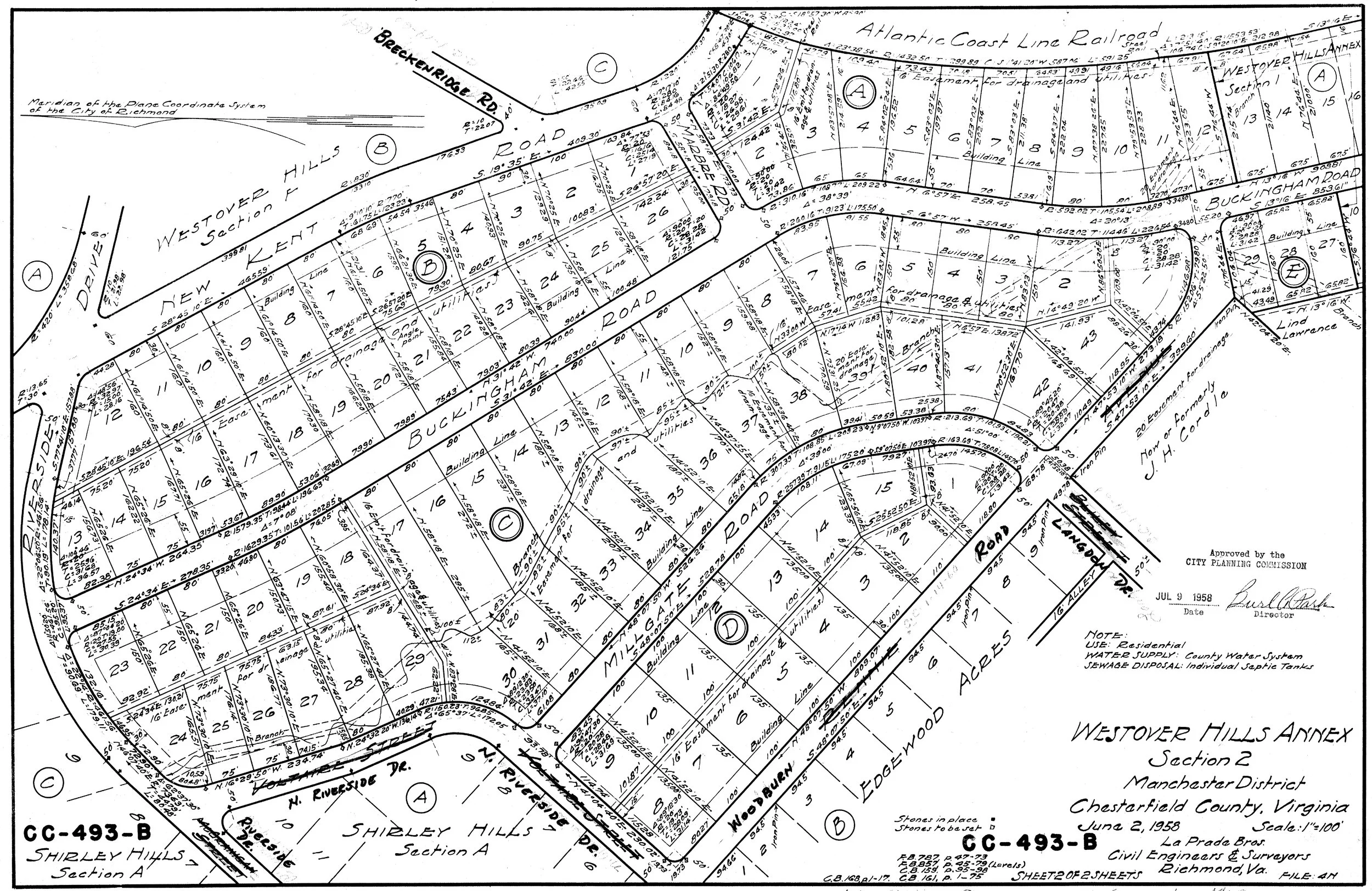
Map E
Led by June Krauss, a resident of North Riverside Dr., a group formed to oppose Collier’s plan. They succeeded in compelling him to build fewer homes on larger lots, which made the project unprofitable. Informed that if they wished to control the future of the “Lawrence Tract,” they would have to buy it, the group formed the “River Hills Corporation.” Thirty members bought shares that raised $270,000. Most of the stockholders lived either in Westover Hills or on streets west of the ACL tracks off Riverside (Breckenridge and New Kent) or Forest Hill (North
Riverside) that had been developed in the 1950s adjacent to the Lawrence property.
In 1985, the River Hills stockholders engaged another builder, R. E. “Dick” Collier (no relation to Gus) and his son-in-law, Warren “Dutch” Goddard, to develop the hilly tract with more substantial homes on larger lots. The first house was completed in 1986. As the new subdivision built out in the 1980s-1990s, Goddard expanded the project, acquiring land south and east of the original tract to create Devonshire and Woodburn courts.
A quasi-creature of Westover Hills, Westover Hills West (along with the older adjacent blocks on the west side of the ACL tracks) became part of the Westover Hills Neighborhood Association in the 1980s. n
The author would like to thank
Debra McClane, Kimberly Chen, and Joe Toler for assistance with this article. If anyone has additional information about street name changes, please contact the author
at jmcoski1@gmail.com.

Map B